After the completion of the spatial analysis, synthesis studies were carried out because the intervention regions for the vision and strategies could be determined on the analytical plane. The methods used in the synthesis and which methods are used according to the themes are given below.
You can access the synthesis report here.
Synthesis Themes

Metodology

The Relationship between Green Space and Socio-Demographic-Cultural Structure
Problem Areas in terms of Access and Sufficiency According to Vulnerable Population
While determining the vulnerability in the city; child population, elderly population and disabled population parameters were taken into account. Each parameter was scored in itself, its weights were considered equally and the average was calculated, and the vulnerability score per unit area was calculated.
Unit areas that are problematic in terms of both access and sufficiency according to the vulnerable population are mostly located in Bağcılar, Esenyurt, Gaziosmanpaşa, Küçükçekmece, Pendik, Sancaktepe, Sultanbeyli and Ümraniye districts. These areas were found in 36 of 39 districts, but not in Adalar, Çatalca and Şile districts.

Green Area and Environmental-Ecological Structure Relationship
Ecological Corridors Critical for Natural Ventilation
Ventilation provides cleaning and transport of polluted air. Height, wind corridors, prevailing wind direction and highways in the prevailing wind direction are important for natural ventilation.

Micro-Climatic (Meso-Climate) Critical Zones
It has been observed that there are micro-scale differences citywide, and that open and green areas are effective in the micro climate. Changes in temperature, precipitation and humidity are observed in the regions where the construction is increased. It is seen that the climatic data is positive at the points where the construction is low and the ratio of open and green areas is high.

Water Resources
Istanbul offers positive data in terms of water resources due to the fact that it has many water basins and generally permeable surfaces in terms of hydrology, and the hydrological function is seen in forest areas.

Flora - Fauna - Vegetation - Biodiversity
According to Noah's Ark National Biodiversity Database shared with the public by the Ministry of Agriculture and Forestry; There are 2267 taxa in the vascular plants group in Istanbul. Of these taxa, 48 are endemic and 3 are locally endemic.
According to the National Red List Index developed by the Ministry of Agriculture and Forestry in accordance with IUCN (World Union for Conservation of Nature and Natural Resources) criteria, there are 25 endangered species. According to the regional distribution of endangered species; There are 73 on the Terkos Kasatura Coasts in Çatalca and Silivri districts, 14 on Ağaçlı Dunes in Eyüpsultan district, 15 on Kilyos Dunes in Sarıyer district, 19 on West Istanbul Pastures at Sultangazi, Başakşehir and Sazlıdere dams, on the Northern Bosphorus in Sarıyer and Beykoz districts. 36 species are endangered, 13 species in the Sahilköy-Şile Coast and 37 species in the Ömerli Basin.

According to the Noah's Ark National Biodiversity Database, there are a total of 483 vertebrate animal species in Istanbul. 1 out of 8 taxa in amphibians, 4 out of 30 taxa in Reptiles, 8 out of 52 taxa in mammals, 37 out of 355 taxa in birds, 5 out of 38 taxa in inland fish are under threat according to IUCN criteria.

Zones with Blue Green Infrastructure and Ecological Function Efficiency
In the synthesis produced by using the unit area model method, two studies were carried out, including the province-wide and metropolitan settlements, since their activities and characteristics are different and require different forms of intervention.
Throughout the province; A total of eleven variables were used: forest areas, agricultural areas, water surfaces, watershed boundaries, natural protected areas, wildlife development area, important plant area-important nature area, urban green area inventory, hydrogeology, stream lines and flood areas. In the metropolitan settlement area, nine variables were used, excluding agricultural areas and forest areas from the scoring.
Regions with blue green infrastructure and ecological function activity throughout the province;
- on the European side; In Çatalca, Silivri, Sarıyer and Eyüpsultan districts,
- on the Anatolian side; It is concentrated in Beykoz, Kartal and Sultanbeyli districts.
Regions with blue green infrastructure and ecological function activity in the metropolitan settlement area;
- on the European side; In Sarıyer and Eyüpsultan districts,
- on the Anatolian side; It is concentrated in Beykoz, Maltepe, Kartal and Sancaktepe districts.


The Relationship between Green Space and Planning
Priority Zones in terms of Open and Green Space Needs
The inadequacy of the amount of green space per capita, the access problem and the user density were evaluated together, and the zones with the highest need for open and green space in Istanbul were determined.
Unit areas in a large part of the central urban residential area of Istanbul, especially in the districts of Esenyurt, Bağcılar, Bahçelievler, Sultangazi, have been determined as the 1st and 2nd priority regions in terms of open and green space need. The unit areas in Silivri, Çatalca, Arnavutköy, Beykoz, Şile districts with less population and the northern regions of Eyüpsultan and Çekmeköy Districts have emerged as the 3rd priority, which is the lowest priority.

Suitable Areas for Public Acquisition
When the acquisition of public spaces is examined spatially; Areas that do not have construction on them and are under the ownership of IMM or the public come to the fore. The northern regions of Beykoz district, the southern regions of Çekmeköy district and the northern regions of Silivri district are examples of these areas. When the regions within the residential areas are examined; work areas and infrastructure areas that require large area uses come to the fore. Maltepe, Tuzla military areas, Atatürk Airport, Cebeci quarries are the areas with the highest public acquisition score.
The European Side Reserve Building Area and the areas planned as open and green areas in the zoning plans in Esenler district are seen as suitable areas for public acquisition as a result of the study. However, these areas are the areas where Article 18 of the Zoning Law will be applied. In terms of application technique, it is not necessary to seek public ownership or expropriation procedures for the acquisition of open and green areas in these areas. Since the population is low in the current situation of the area, it is not a prominent region in terms of green space need. Since the open and green areas planned here will serve the new population to be attracted to the region, they do not create a potential to meet the current green space need of the city. In addition, the European Side Reserve Building Area, which is aimed to be opened for construction through the Kanal Istanbul project and whose zoning plans have been approved, includes the Sazlıdere Dam, which is important in terms of blue-green infrastructure, and agriculture and forest areas. Preventing urban sprawl in this region, preserving water resources and natural quality are of critical importance in terms of the ecological values of the city.

Need for Open and Green Space and Public Acquisition Evaluation
When the Istanbul provincial borders of the crossover result are examined, it is seen that the areas where the priority of the need for green space and the convenience of public acquisition are 1st degree are scattered within the settlement area. Areas such as the northern regions of Beylikdüzü, Gaziosmanpaşa and Bayrampaşa districts, the border region of Beykoz and Üsküdar districts, and the south of Sarıyer district have been determined as the most suitable areas in terms of public acquisition and the highest priority in terms of green space need.

Sensitive Areas Outside the Residential Area and Priority Response Areas in the Metropolitan Residential Area
While evaluating the metropolitan settlement area; 1st and 2nd degree priority areas in terms of green space need, 1st and 2nd degree priority areas in terms of green space need, 1st and 2nd degree suitable areas in terms of public acquisition of green areas, blue-green infrastructure system in metropolitan settlements and 3rd degree efficiency in terms of ecological function. These regions were used to determine the areas to be intervened in the unit area synthesis model. The blue green infrastructure system affects the unit area synthesis model in the opposite direction compared to the other three variables. Because it will be necessary to intervene in the areas that are weak in terms of blue-green infrastructure in the settlement area, the 3rd degree active areas are included in the unit area synthesis model to get the highest score.
Unit areas outside the metropolitan settlement area and which have sensitive areas in terms of protection-use balance are scored within themselves; The results obtained from a total of 11 variables: forest areas, agricultural areas, water surfaces, watershed boundaries, natural protected areas, wildlife development area, important plant area-important nature area, urban green area inventory, hydrogeology, stream lines and flood areas. was processed into unit areas using
Sensitive areas outside the residential area that arise in terms of protection-use balance and priority needs, priority public acquisition, fragile population, blue-green infrastructure and intervention areas with ecological function in the metropolitan residential area are discussed together. It has been provided as a guide for strategic action plans to be created in the short, medium and long term citywide.

Relationship between Green Areas and Historical, Cultural Heritage and Tourism
Green Areas Registered as Protected Areas
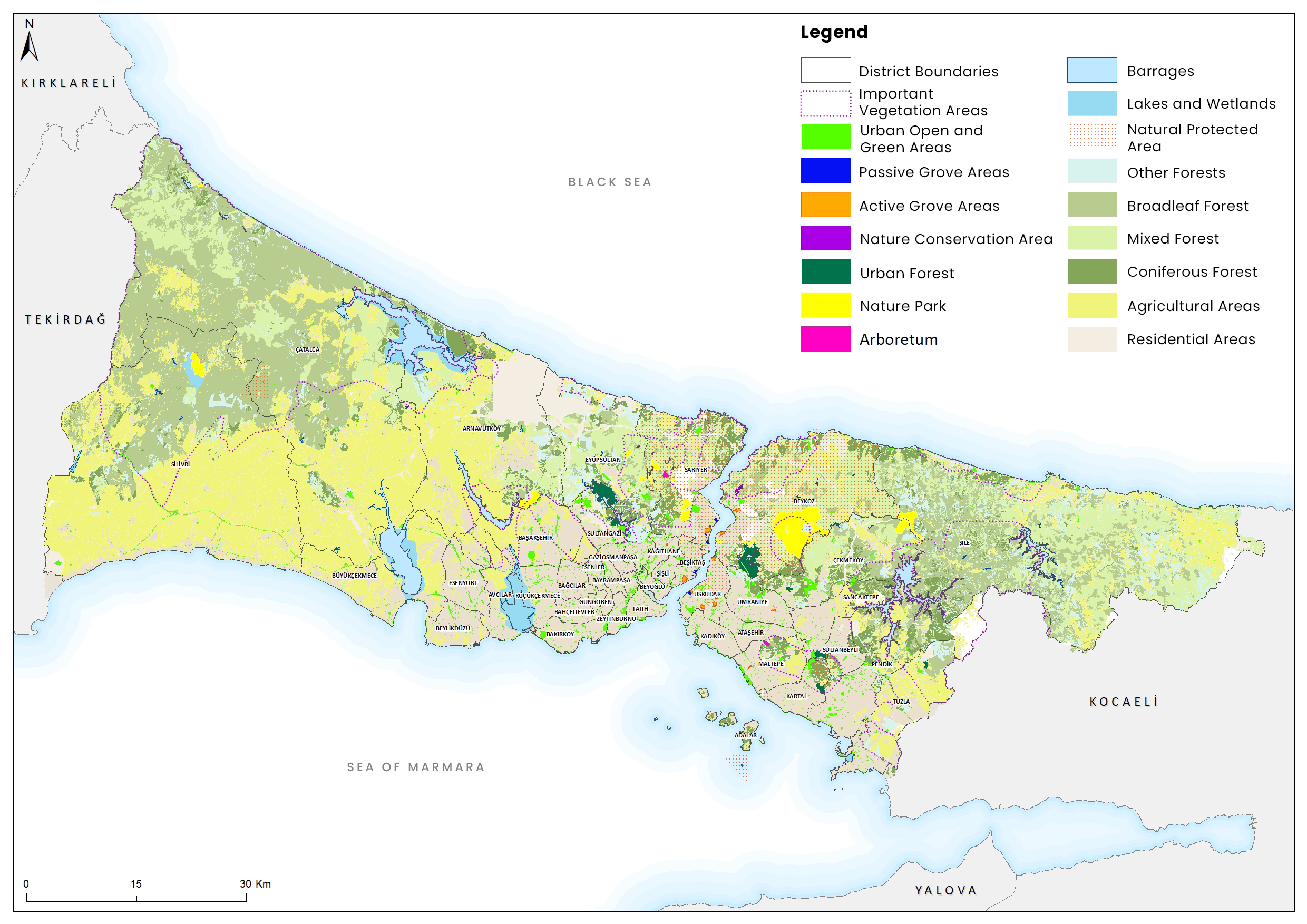
There are green areas in the city that are directly registered as protected areas. These; Abbasağa Park, Yıldız Woods, Emirgan Woods, Big and Small Camlica Woods, Validebağ Woods, Yoghurtçu Park and Florya Atatürk Forest, which serve as a city park; Polonezköy Nature Park, which serves as a recreational forest area, and Danamandıra Nature Park, and Karacaahmet Cemetery, which is classified as a passive green area.

Green Spaces in UNESCO World Heritage Sites
The "Convention on the Protection of the World Cultural and Natural Heritage" adopted at the 17th General Conference of UNESCO in 1972, to introduce the cultural and natural assets of superior universal value, which are accepted as the common heritage of all humanity, to the world, and to create the awareness in the society to protect this universal heritage. and to provide the necessary cooperation for the survival of these values, which are deteriorated and destroyed for various reasons.
The "Historical Areas of Istanbul", consisting of four regions, was included in the World Heritage List, which was started to be created by the World Heritage Committee in 1978. These four regions with outstanding universal value; Archaeological Park in Sarayburnu on the Historic Peninsula; Süleymaniye Region with its Süleymaniye Mosque Complex, bazaars and local settlement; It is the site of the Land Walls, which includes the settlement around the current Zeyrek Mosque, formerly the Church of Pantokrator, and the Zeyrek District and the remains of the former Blachernae Palace, which stretched on either side of the Theodosian walls.

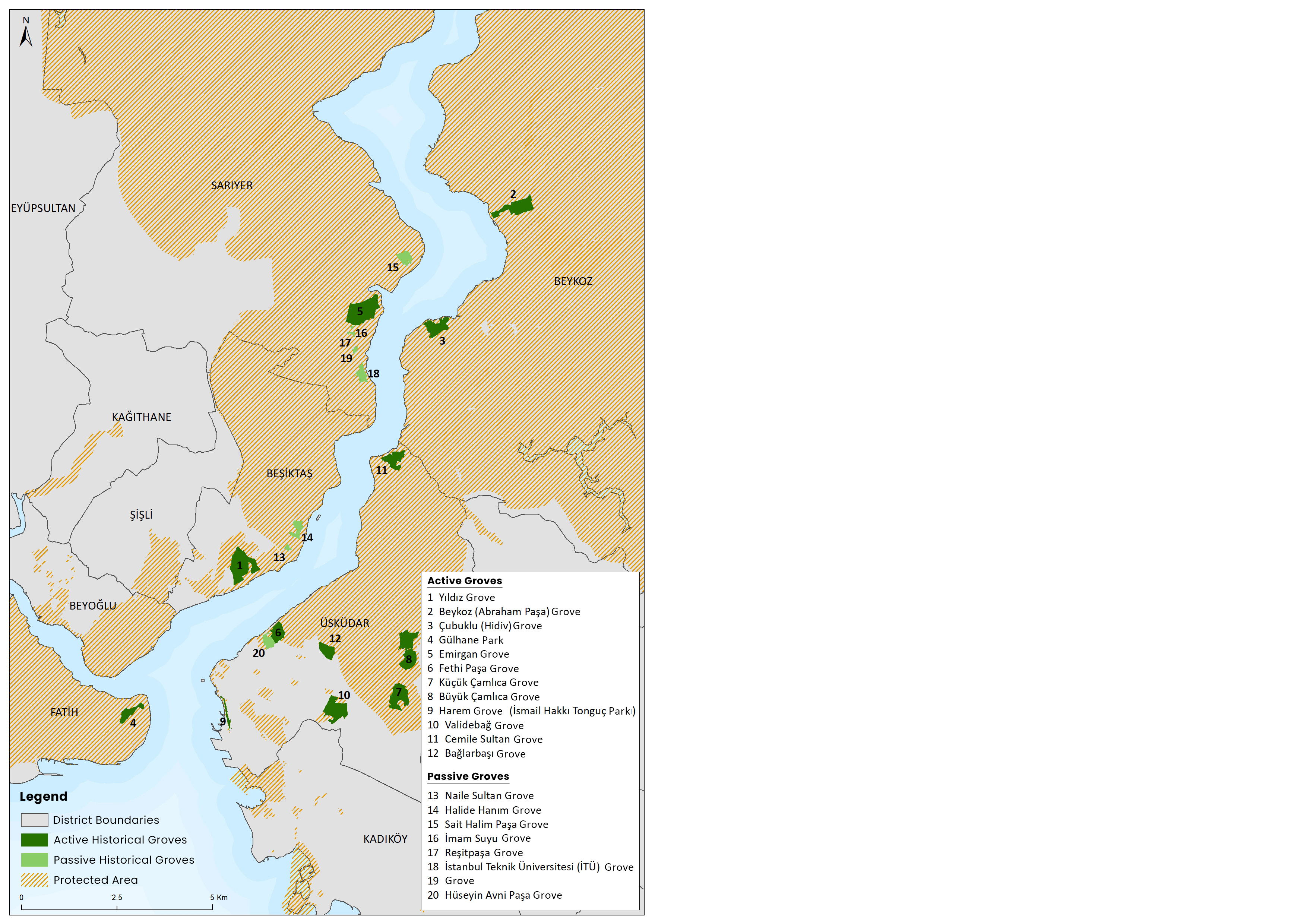
Historical Groves
Istanbul is a city that has many palaces, pavilions, groves and parks as a historical heritage. While the groves that have survived until today are usually the gardens of old palaces and mansions, they are wooded areas that were opened to the public and used for recreation in the Republican period.
One of the basic principles of conservation is to recognize, protect and improve the relationship between natural and cultural landscape elements in historical environments. Historic groves are invaluable cultural monuments and urban living environments of today. There are groves in the status of passive and active green areas in Istanbul. All groves were examined in detail in the analysis report. In this section, historical groves that are registered as groves are discussed.
While 12 of the historical groves are actively used for recreation, 8 of them are passive green areas. While making this distinction, public use was taken as a basis; Woods such as Naile Sultan Grove, which is privately owned, or Halide Hanım Grove, which is in public property but not open to the public, are classified as passive. Cemile Sultan Grove and Bağlarbaşı Grove, which are owned by a foundation and can be used with membership; It is a social facility for foundation members, but it has been considered as an active status here, considering that it meets a certain recreational need, albeit for a limited number of people.
Natural and Human Originated Risks in Green Areas
Green areas are at risk due to natural disasters and indirect or direct effects created by human use. In addition to natural disasters such as floods, landslides, erosion, earthquakes, there are also dangers such as loss of green space due to urban sprawl or vandalism. The presence of chaotic situations such as increasing population, dense and uncontrolled construction, and climate change significantly affect the pressure on green areas, their protection and sustainability.
Scope of work; Risk assessments were made for open and green spaces in Istanbul under the headings of climate, flood, fire, landslide, erosion, drought, tsunami, disaster assembly areas, urban sprawl and vandalism.
Surface Temperatures
As a result of the measurements made in 2017, the number of green areas considered at risk (above 370C) is 725, according to the surface temperatures varying between 22-470C throughout the city. Of these, 394 are active green areas and 331 are passive green areas. It is seen that the green areas at risk are mostly concentrated in the European Side, especially in Bağcılar, Gaziosmanpaşa, Esenler and Sultangazi districts.

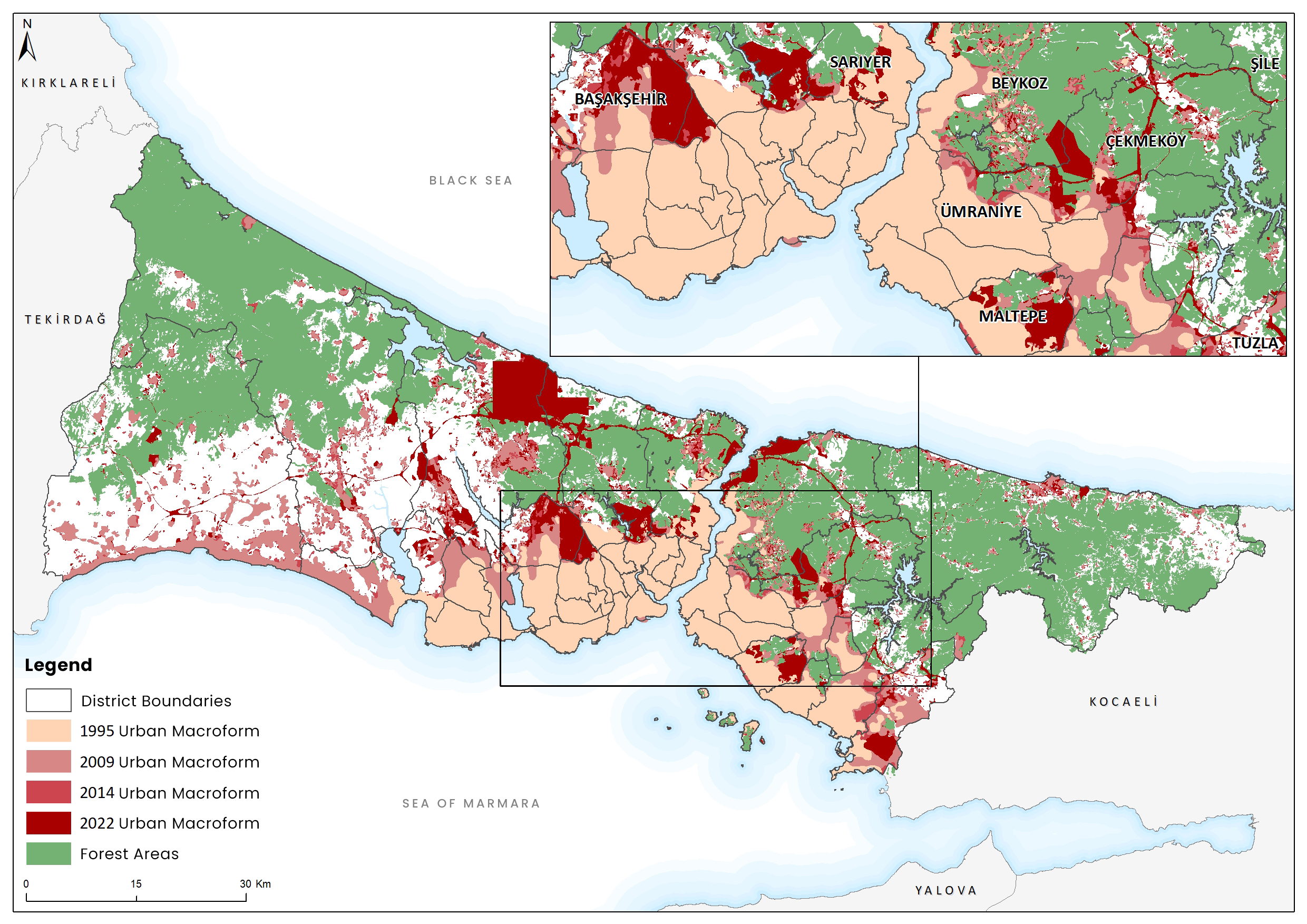
Urban Sprawl
The urban macroforms of the years 1995 - 2009 - 2014 used in the Istanbul Urban Resilience study completed in 2019, the urban macroform obtained from the land use study of 2022 and the forest areas were superposed and the spatial expansion trends of the city in the historical process were compared.
Looking at the historical process, it can be said that the urban macroform of Istanbul developed in the east-west axis, with the west in the foreground between 1995 and 2009, this development shifted to the north between 2009 and 2014, and the implementations, especially the airport, in the process until 2022, completely oriented towards the north. .
Considering the forest areas covering the north of Istanbul, it is seen that these areas are under constant threat. Until 2022, structuring, which spreads especially in peripheral districts such as Başakşehir, Eyüpsultan, Çekmeköy and Beykoz, is seen as the primary risk for forest areas and green areas in these districts.