Before the spatial analysis phase, a SWOT analysis of Istanbul's green areas was prepared as a result of the focus group meetings held in March - June 2022 and expert opinions. Within the green areas of Istanbul, its strengths, weaknesses, opportunities and threats were evaluated under 5 different themes. These themes are:
1. Environmental/Ecological
2. Social/Demographic
3. Planning/Design
4. Management/Legislation
5. Economics/Finance
You can access the SWOT Analysis report here.
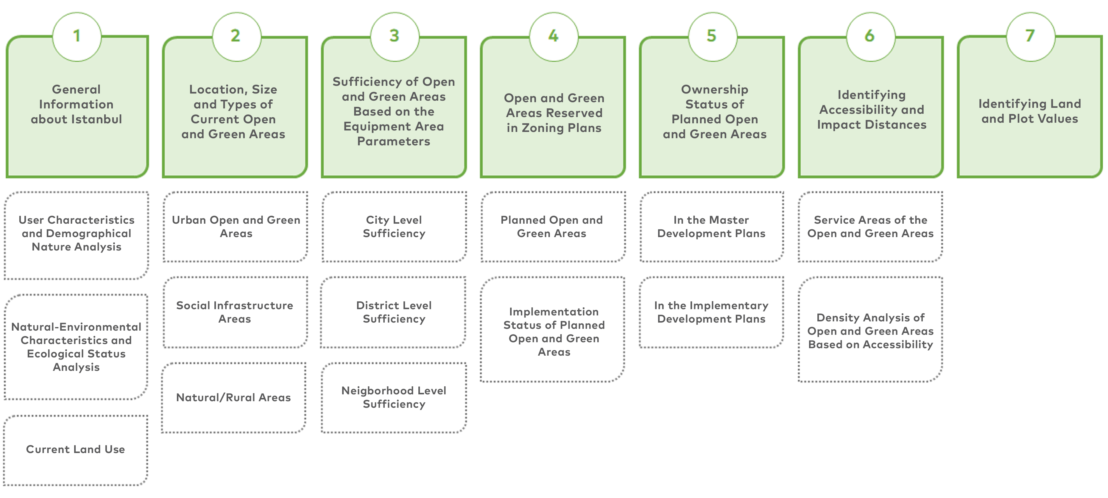
Spatial analyzes made within the scope of the study are as follows. You can access the details of the analyzes with examples from the spatial analysis report.
Analysis Topics
Current Land Use
Istanbul, with forests in the north, agricultural areas in the west and residential areas in the south, has an area of 546,242.30 hectares including water surfaces. When the areal distribution of land usage is observed, 43.10% consists of forest areas, 27.35% consists of residential areas, 24.27% consists of agricultural areas, 2.57% consists of mining and excavation areas, 2.49% consists of lakes, 0.21% consists of sandy and rocky areas.
Change of Land Use in Istanbul Between 2009 - 2022
It has been determined that residential areas in Istanbul have increased by 7.10% over a 13-year period, while forest areas have decreased by 4.03% and agricultural areas by 3.37%.
Forest Areas by Function
When the areas that lost their forest character due to the 3rd Airport and the Northern Marmara Highway are removed, the forest areas are spread over a total area of 257,497.10 hectares, according to the 2012 stand map. 55.38% of these areas are on the European Side and 44.62% are on the Anatolian Side. Among all forest areas, protected forest areas have a rate of 17%, protected forest areas have a ratio of 26%, operated forest areas have a ratio of 45%, recreational forest areas have a ratio of 2% and other forest areas have a ratio of 9%.
Spatial Distribution of Agriculture Areas
Of these areas, 66% is planted area, 0.15% is greenhouse production area, 4% is pasture area and 29% is fields suitable for pasture.
Open and Green Spaces in Istanbul
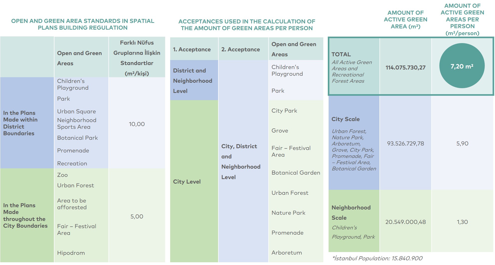
Urban open and green areas were evaluated at 3 levels in the open and green areas inventory, which was prepared to cover the urban residential area of Istanbul. In the table below, the ratio of urban open and green areas to the total area is given according to the classification made. Accordingly, recreational forest areas, which are taken into account in the calculation of the amount of green space per capita, have a rate of 46.47%, while active green areas have a rate of 19.2%. The rate of parks in the city is 11.58%, the rate of nature parks is 27.60%, and the rate of urban forests is 9.90%.
Open and Green Area Adequacy According to Reinforcement Areas Parameters
The amount of green space per capita in Istanbul is 7.20 square meters by 2022.
In the table below, the open and green space standards in the Spatial Plans Construction Regulation, the acceptances used within the scope of the qualification and the amount of green space per person are given at different scales. 2nd acceptance (active green areas and recreational forest areas) was used to calculate the amount of green space per capita on the basis of district and neighborhood.
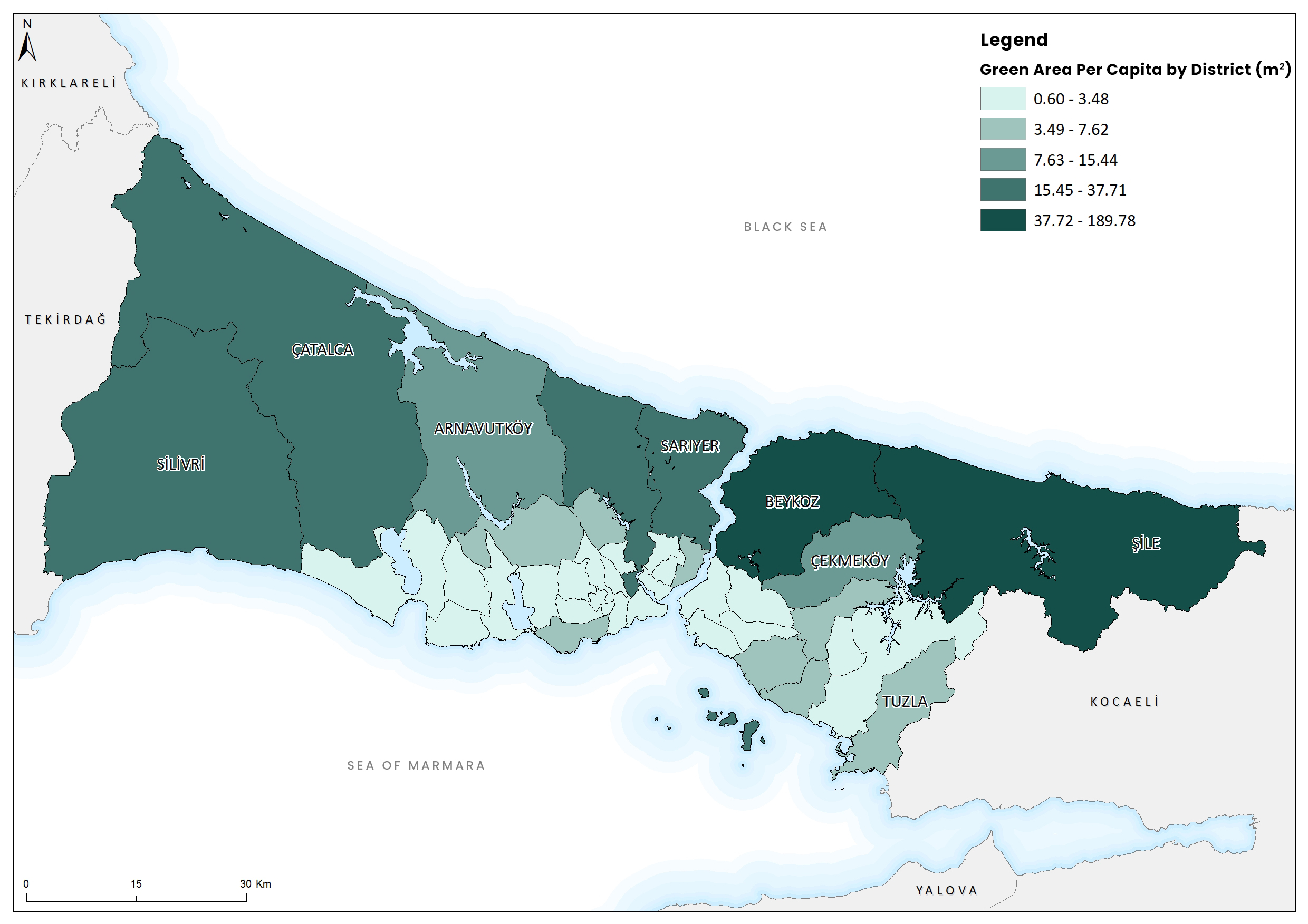
According to the adequacy analysis made at the city scale and district scale; Urban green areas in Istanbul are above the standard with 5.90 m²/person. However, active green areas at the district scale are well below the standard with 1.30 m²/person. Based on this determination, it is possible to say that priority should be given to the scale of the district in the new active green areas.
The districts with the highest green area size per capita are Şile and Beykoz districts on the Anatolian side. The most obvious reason for this is the fact that the resident population is much less than in other districts and that open and green areas such as recreation areas, nature parks and city parks are concentrated in these districts. The size of open and green areas per capita in these districts is greater than 100 square meters. After Şile and Beykoz, the other districts with the highest green area size per capita are respectively; Islands are Silivri, Eyüpsultan, Çatalca, Sarıyer, Arnavutköy and Çekmeköy.
The districts with the lowest numbers are respectively; Bağcılar, Güngören, Bahçelievler, Gaziosmanpaşa, Esenyurt, Esenler and Şişli. These districts, which have less than 1 square meter of open and green area per capita, are generally districts with high building density and population.
According to the current neighborhood boundaries, there are 978 neighborhoods within the provincial borders of Istanbul. In 15 neighborhoods, there is no population due to the forest and military areas.
According to the sufficiency analysis at the neighborhood level, the number of neighborhoods (with population) without children’s playground is 107. It was determined that 79 neighborhoods do not have any active green areas and recreational forest area. When an examination was made according to the standards of Spatial Plans Building Regulation it was determined that there were only 54 neighborhoods in Istanbul that meet the standards compared to the first admission (only children’s playground and parks). According to the second admission, it was seen that the amount of green area per person was below 10.75 m2 for 75.4% of the people living in the neighborhoods in Istanbul.
Implementation Status of Planned Open and Green Spaces
When the distribution of open and green areas in the current master development plans throughout Istanbul is examined; A total of 32,816,81 hectares of open and green areas are planned. 5,496.41 hectares of the areas planned as open and green areas are currently used as open and green areas. Planned open and green areas; The highest rate of implementation is in the districts of Zeytinburnu (67.16%), Bayrampaşa (65.83%) and Kadıköy (59.87%), Ataşehir (0.90%), Arnavutköy (2.82%) and Çatalca (4.80%) It is seen that the rate of implementation is the lowest in the districts. When the open and green area functions determined in the Master Zoning Plans are compared with the existing open and green areas, 16.75% of the planned areas are currently used as open and green areas.
Accessibility in Open and Green Spaces
The total service area of healthy adult individuals who can access open and green areas is 82,816.40 hectares, while the total service area of disadvantaged individuals who can access open and green areas is 52,674.32 hectares. When calculating, the walking speed for a healthy adult is assumed to be 6 km/h on a 5% downward gradient; For disadvantaged individuals such as physically disabled people, parents with strollers, small children, the elderly and the disabled, the average is 3 km/h.
Within the scope of the analysis, point population data obtained by processing the Address-Based Population Registration System and Spatial Address Registration System data of 2020 was used. In the population data in question, individuals between the ages of 15 and 65 are considered as the adult population. As a result of the analysis, the population data served by the open and green areas within the effect range was determined. According to population data, there are 11,274,943 adults between the ages of 15 and 65 in Istanbul. It has been determined that 87.2% of this population can access open and green areas by walking for 5 minutes.
In the analysis, in which the service areas of disadvantaged individuals were examined together with the population, children under the age of 15 and individuals over the age of 65 were taken into account. However, although people with physical disabilities, parents with strollers and pregnant women were included in the disadvantaged group, they could not be included in the analysis due to the lack of spatial data. According to population data, there are 4.404.053 people under the age of 15 and over the age of 65 in Istanbul. When the population data and service areas of the groups under the age of 15 and over the age of 65 are analyzed, it has been determined that 40% of this age group cannot receive service from open and green areas.
_en.jpg)
_en.jpg)
Service Areas Added with Implementation Zoning Plans
According to the results of the analysis, the additional area size that adults can reach with a 5-minute walk is 75,778 hectares. Compared to the current situation, the service area for adult individuals will increase by 92% with the implementation of all active green areas in the plans and the protection of open and green areas in the current situation. The low rate of implementation of active green areas included in the implementation development plans is one of the reasons for this high value.
According to the results of the analysis made for the disadvantaged individuals, the size of the active green areas in the plans for the disadvantaged individuals is 72,105 hectares, excluding the currently accessible areas. Compared to the current situation, the service area for disadvantaged individuals will increase by 137% with the implementation of all active green areas in the plans and the protection of open and green areas in the current situation.
User Density in Open and Green Spaces
With the analysis, the closest open and green space accessible to the population in Istanbul has been determined. With the assumption that the population uses the closest open and green areas at the same time, the user density of open and green areas is calculated on the basis of area per person. According to the results of the analysis, it has been determined that 26% of the open and green areas have an area between 1 and 5 m² for a person, and 16% of them have an area between 0.5 and 1 m². 55% of open and green areas in Istanbul have an open and green area size per capita below 1 m². The ratio of parks that meet the 10 m² standard of the Spatial Plans Construction Regulation is 12%.